
Chesterfield ZIP Code Coverage Across 17 Areas
The official Chesterfield GIS ZIP map, created in September 2021, identifies 17 county coverage areas. It is an orientation tool. The labels below are the map's documented community and mailing designations, not a claim that every address in a ZIP sits inside Chesterfield County. The source does not identify a specific post-office station for every ZIP, so the table uses the verified mailing designation instead.
| ZIP | County-map area | Post-office or mailing designation | Record-search note |
|---|---|---|---|
| 23112 | Midlothian | Midlothian | May serve adjoining locality edges; verify the address with USPS. |
| 23113 | Midlothian | Midlothian | Delivery geography does not follow a municipal line. |
| 23114 | Midlothian | Midlothian | Midlothian postal area. |
| 23120 | Moseley | Moseley | New subdivision growth can change delivery ranges. |
| ZIP | County-map area | Post-office or mailing designation | Record-search note |
|---|---|---|---|
| 23224 | North Chesterfield | Richmond or North Chesterfield | Richmond delivery geography can cross county and city boundaries. |
| 23225 | North Chesterfield | Richmond or North Chesterfield | Use the USPS standardized city; the ZIP is not a county boundary. |
| 23234 | North Chesterfield | Richmond or North Chesterfield | South and east county, plus Richmond-edge delivery geography. |
| 23235 | North Chesterfield | Richmond or North Chesterfield | Midlothian Turnpike and Bon Air area context. |
| 23236 | North Chesterfield | North Chesterfield or Richmond | Map area includes several neighborhoods and routes. |
| 23237 | North Chesterfield | Richmond or North Chesterfield | Verify the parcel's situs jurisdiction separately. |
| ZIP | County-map area | Post-office or mailing designation | Record-search note |
|---|---|---|---|
| 23803 | South Chesterfield | Petersburg or South Chesterfield | A ZIP label is not a city-limit statement. |
| 23806 | Virginia State University | Petersburg or VSU | Institutional-style map area; verify each delivery address. |
| 23831 | Chester | Chester | County-map Chester area. |
| 23832 | Chesterfield | Chesterfield | County seat mailing area. |
| 23834 | South Chesterfield | Colonial Heights or South Chesterfield | USPS city field can differ from the county community. |
| 23836 | Chester | Chester | County-map Chester area. |
| 23838 | Chesterfield | Chesterfield | County-map Chesterfield area. |
Chesterfield is a county south of Richmond, not a city with one downtown numbering pattern. Its addresses follow county roads, subdivisions, rural routes, and historic communities. Use the ZIP map to orient a search, then use USPS for delivery, the parcel record for a physical location, and the recorded plat or deed for jurisdiction and legal-description questions.
Note: The county map expressly is not a land-conveyance document, so a ZIP boundary should never substitute for a recorded plat.
Chesterfield Delivery Areas: Midlothian and Moseley
The map groups 23112, 23113, and 23114 under Midlothian and 23120 under Moseley. These are useful first labels for a search, especially where a historical account, yearbook, directory, or family record gives only a community name. They are still mailing geography. A result for Midlothian or Moseley does not establish the governing records office, precinct, subdivision, or exact parcel by itself.
For an address on a community edge, keep the physical address, mailing address, ZIP, and legal description in separate notes. Chesterfield Real Estate Assessment Data can distinguish a property situs from an owner's tax mailing address, while a deed keys on parties and legal description rather than a ZIP. That distinction prevents a mailing label from being mistaken for a current residence or a title conclusion.
Chesterfield Richmond-Edge Delivery Areas
North Chesterfield appears on the county map with 23224, 23225, 23234, 23235, 23236, and 23237. Several carry Richmond or North Chesterfield as recognized mailing cities. That is a normal delivery arrangement, not a jurisdiction finding. A Chesterfield parcel can have a Richmond mailing city, and a ZIP can continue across a county or city line. Search the property situs and date before deciding whether a record belongs with Chesterfield, Richmond, or another locality.
Historic research needs an added date check. Manchester became an independent city in 1870, Colonial Heights separated in 1926, and Richmond annexed 27 square miles and more than 47,000 former Chesterfield residents in 1970. A current North Chesterfield ZIP code cannot resolve those earlier custodian changes. Compare historic place names with the directory, map, court, or land source from the same period.
Note: A Richmond mailing name is a postal description and should not be treated as a shortcut to the county or city record custodian.
Chesterfield Chester and South County Delivery
The remaining map areas cover South Chesterfield, Virginia State University, Chester, and Chesterfield itself. They include 23803, 23806, 23831, 23832, 23834, 23836, and 23838. The 23806 map area is labeled Virginia State University, with Petersburg or VSU as the mailing designation. Treat it as an institutional-style delivery area and verify an individual address before using that label in a records search.
The 23832 Chesterfield area includes the county-seat mailing area. The research identifies 9500 Courthouse Road as a Chesterfield 23832 address. That fact is useful as a local example of the map label, but it does not turn 23832 into a countywide records boundary. The county's communities and postal cities overlap in ways that make parcel, address, and legal-description checks more reliable than a ZIP-only search.
Verify Chesterfield ZIPs With USPS
Use the USPS Look Up a ZIP Code tool to verify a particular delivery address. Its available modes are Find by Address, Find by City & State, and Find Cities by ZIP. Find by Address accepts a street address with city and state, or a street address with ZIP. City and state can return ZIP choices, while a ZIP search returns recognized cities. USPS advises users to use the standardized city name and warns that a ZIP result does not confirm that a particular person or company is at the address.
| Find by Address | Street address plus city and state, or street address plus ZIP; use for a particular delivery address. |
|---|---|
| Find by City & State | City and state; use to identify ZIP choices for a place label. |
| Find Cities by ZIP | ZIP only; use to see the recognized city or cities associated with the delivery area. |
USPS is the delivery check. The Chesterfield Parcel Viewer and the Circuit Court Clerk's records answer different questions. A recorded deed uses legal description and party names, while the Parcel Viewer shows geometry, subdivision, schools, political districts, and other location context. Keep those functions distinct when an address sits near Richmond, Colonial Heights, Petersburg, or another boundary.
Find Residents Within a Chesterfield ZIP
A ZIP can organize the first pass, but the documented Chesterfield tools do not provide one general ZIP-wide resident list. Begin with an address verified by USPS, then move to the parcel and map records that identify the exact property. The reliable route is address to parcel, parcel to owner or legal description, then a separate name-organized land search if a recorded transaction needs review. That process avoids treating a delivery area as a household roster.
- Use USPS to confirm the standardized address, ZIP, and recognized mailing city for the property being checked.
- Open the Chesterfield Parcel Viewer, search the address, and note the parcel, subdivision, districts, and mapped context.
- Use the parcel result to open or compare the Chesterfield assessment record, keeping situs and tax mailing addresses separate.
- If a recorded transaction is relevant, search the Circuit Clerk's land index by the owner or party name, not by the ZIP or street number.
- For a full named-street chain after an address is narrowed, use the Chesterfield street directory route.
Public parcel ownership and an address match do not establish every person who lives there. Private occupancy, utility, DMV, and protected-address information is not a ZIP lookup product. Keep the work tied to the stated record and use it only for lawful personal research.
Chesterfield ZIP Search Modes
Use only the search modes the sources document. Chesterfield Real Estate Assessment Data, or READ, supports broad address or owner searching and advanced property filters. Its public JavaScript parameter list does not confirm a ZIP filter, so it should not be presented as a ZIP-wide assessment search. The Parcel Viewer can display and browse the county ZIP layer, but a parcel or address query remains the reliable route to a specific location.
The READ assessment search is shown here because it is the appropriate property follow-up after a Chesterfield ZIP code has been narrowed to a real address.
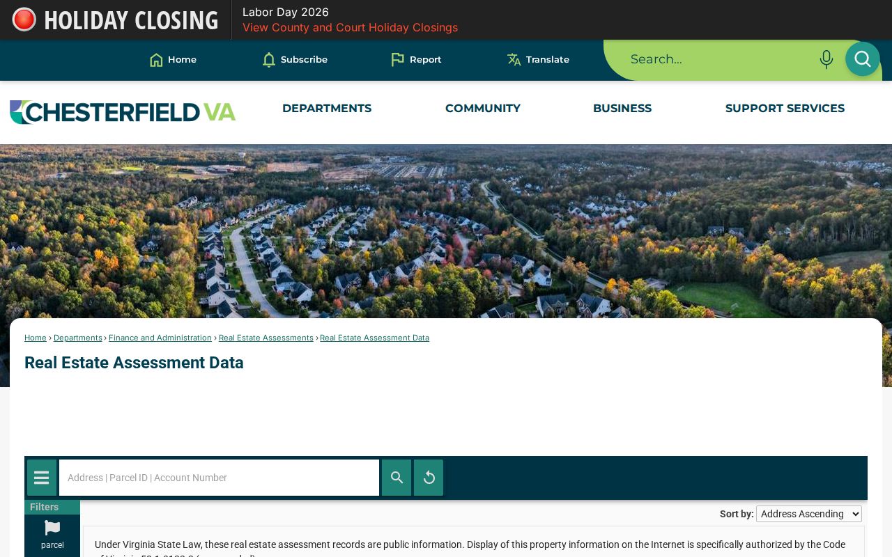
READ can bridge an address to parcel and assessment information, but the research did not verify a user-facing ZIP control. Use the verified address and parcel result instead of assuming an advanced filter will return every property in a ZIP.
| Tool | Documented mode | ZIP use | Limit |
|---|---|---|---|
| READ | Basic address or owner query; advanced property filters | Follow a verified address to a parcel | No verified ZIP filter in the documented parameter list |
| Parcel Viewer | Address or street search, parcel click, ZIP-layer browsing | Orient within a ZIP then inspect a parcel | Map is not a title or land-conveyance record |
| Virginia Citizen Portal | Registration-status and address or polling-place tools | Address-based, not a bulk ZIP browser | Full voter-list products use authorized-purpose requests and no verified ZIP filter |
| ELM | Address, parcel, or record-number search | Check a known address in a ZIP | No verified ZIP-wide public search |
| Virginia State Police registry | ZIP, address-radius, name, county or city, and map search | Direct ZIP-capable registry query | Limited to registry records and statutory purposes |
Note: The availability of one ZIP field in a specialized registry does not create a general Chesterfield ZIP-based resident search.
Chesterfield ZIPs, Precincts, and Districts
A ZIP code, voting precinct, school district, and political district are different layers. Chesterfield has 78 precincts, and the county reported 288,073 registered voters, 275,669 active voters, and 12,404 inactive voters in July 2026. Those figures are aggregate context only. A single ZIP can contain parts of several precincts, and a precinct can cross ZIP boundaries. Use the address-based polling-place or registration-status tools in the Virginia Department of Elections Citizen Portal for current district information.
Virginia's public lookup is for one voter's status, history, and polling information, not a bulk street browser. Full list products have separate authorized-purpose request rules and locality, precinct or election-district filters. The researched form does not document a ZIP filter. A protected voter can use a Virginia post-office box in place of a physical residence on public lists, so a missing address result does not establish nonresidence.
Chesterfield Delivery Boundaries and City Lines
Chesterfield County has no incorporated city within its present boundaries, so there is no Chesterfield city limit for a ZIP code to match. The real issue is the difference between delivery geography and county or neighboring-city jurisdiction. Richmond, Colonial Heights, Petersburg, Hopewell, and other nearby localities appear around the county ZIP map. A Chesterfield address may use a Richmond mailing city, while a ZIP can also serve addresses across a city or county line.
For an old address, historic boundaries add another layer. Manchester records can appear under Richmond collections, and the 1970 Richmond annexation shifted many former Chesterfield residents into another jurisdiction. Use the date, physical address, parcel, and legal description together. USPS verifies delivery; the Parcel Viewer gives geographic context; the Clerk's recorded plat or deed provides the official property record.
- ZIP code
- A Postal Service delivery area, not a city, county, precinct, school district, or legal property boundary.
- ZIP+4
- An added four-digit delivery detail used with a base ZIP; it does not change the governmental jurisdiction.
- PO box ZIP
- A ZIP associated with post-office box delivery, which may differ from the physical address ZIP.
- Unique ZIP
- A ZIP associated with a single organization or institution; verify each address before assuming that status.
- Carrier route
- A Postal Service delivery sequence within an area, not a public list of everyone at the addresses on that route.